 Contact
Understanding Vehicle Movements Around Towns and Cities
HGV Movements & Strategy
Heavy Goods Vehicles (HGVs) are a vital component in supporting a town and cities economic growth to service local residents, businesses and industrial estates, however with continued growth comes increased concerns on road network reliability and the environmental impact this brings.
Whilst most County Councils have a freight strategy and provide advice for haulage companies and HGV drivers with Advisory Lorry Route Maps, to promote routes that have the most appropriate strategic and primary roads, the county councils often can’t track how well this is adhered to and once these routes have been advised, how truly optimal they are.
At the end of the day lorries are permitted to use any classification of road for access and deliveries. Understanding the impact of HGV traffic on these routes helps to shape the network of the future. Low/zero emissions last mile delivery alternatives may need to be considered to not only to reduce the impact of a thriving economic hotspot, that draws additional traffic to it, but also to relieve the network of these larger vehicles to improve journey reliability and make a cleaner and safer road network for local residents.
Before a freight strategy can be evolved, a local authority needs to understand how their road network is being utilised. Detailed chassis-based classification data is required.
TagMaster’s Compact Traffic Counter is designed and optimised for traditional count classifier requirements and enables you to use live data as well as historical data. There are many benefits to using live data including monitoring traffic in real time, gathering speed and flow information, monitoring congestion and providing an insight into estimated emissions.
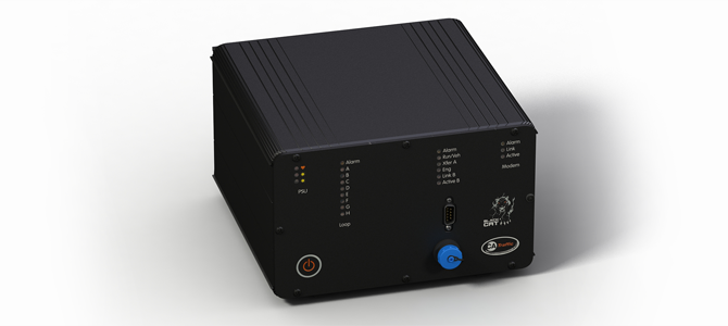
The Compact is an easy-to-use standalone system using 3G/4G communications with battery or solar power options. It uses embedded inductive loops in the road surface for long-term data collection. It provides an economical and effective solution for monitoring anything from a one-lane road to a sixteen-lane high-speed highway and achieves a vehicle count in excess of 99% accuracy.
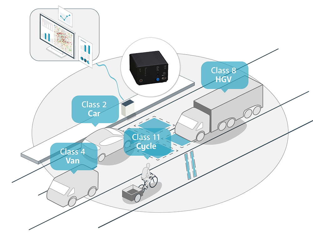
Vehicle Classification
The Compact collects chassis-based data to break vehicles down to the following classes:
1 Motorcycle
2 Car / Light Van
3 Car + Trailer / Light Van + Trailer
4 Heavy Van
5 Light Goods
6 Rigid
7 Rigid + Trailer
8 Articulated HGVs
9 Minibus
10 Bus / Coach
11 Cyclists
Profiling vehicle types using the road network allows councils to fully understand how their road network is being used and focus areas for improvements. For example, transport planners may see an increase in HGVs on the road network, which directly impacts the flow and average speed, slows down the flow of traffic and ultimately causes congestion. The cause of this congestion can be reviewed to understand if changes can be made to how the HGV traffic merges with the road network from distribution centres or whether green light optimisation schemes would benefit this area to ensure that HGV traffic doesn’t become stop/start and flows freely to alleviate congestion.
Estimated Emissions & Air Quality
Detailed vehicle chassis data provides a foundation for analysis beyond that which is initially being captured from the roadside. This data type allows for further context to be added when Councils are making informed decisions by integrating complementary datasets such as the DEFRA emissions factors toolkit.
Individual vehicle records that contain chassis-based identifiers along with speed data can be used to run through the Emissions Factor Toolkit (EFT) to generate estimated emissions reports. Councils can then begin to understand how the percentage of certain vehicle classifications can contribute to estimated emissions values.
When more context is added to the live classification data, it is possible for Councils to start being proactive with the management of the road network. Emissions based route diversion schemes can be implemented to alleviate dangerous emissions levels during peak or abnormal traffic conditions. Additionally, Councils can use historical data to understand why they are hitting these thresholds and plan what can be done to solve the issues rather than simply react to them.
When analysing the data, it is clear to see how many HGVs are using the network as previously mentioned but taking a step back to look at other vehicle classifications opens new opportunity for change.
With the steep increase of online retail and the decline of high street shopping, delivery services are on the rise and adding to the growing number of vehicles on our roads. An increase in larger vehicles not only means that more road space is being used per vehicle, but the emissions outputs from these vehicles is having a knock-on effect to the air quality. A focus on Class 4: Heavy Vans or long wheelbase vans, highlights the increase of this activity over recent years.
The introduction of Clean Air Zones is doing its part to ensure that more modern and efficient vehicles are being used to improve air quality, but this does nothing for the improvement of congestion. By extending the scope of classification data to also include in road/off road cycle capture, it takes another step to building a stronger picture of what is happening on the network.
Eco friendly last mile delivery options can be promoted in high density areas to not only relieve the effects on air quality, but also ease the reliance on the road network to improve travel experience for local residents. Monitoring the uptake of implemented cycle lanes or even looking at demand vs development use cases will support the Councils future transport plans with a more rounded view of improvement actions without the requirement to invest in consultants to correlate the data sets that are easily digestible on platforms such as VDA-Net.
Summary
In summary, from the data gathered and analysed via traffic monitoring, councils can understand the Vehicle movement in and around our towns and cities. Traffic managers and transport planners can use the data from TagMaster’s traffic monitoring solutions to make informed decisions and help justify investments to improve their operations.
Products:
Next Step: